
Thank you for supporting this site ❤️
Make a donation
Make a donation
Gear up for your next adventure:
As an Amazon Associate, this site earns from qualifying purchases at no extra cost to you.
Braka topographic map
Click on the map to display elevation.
Thank you for supporting this site ❤️
Make a donation
Make a donation
Gear up for your next adventure:
As an Amazon Associate, this site earns from qualifying purchases at no extra cost to you.
About this map
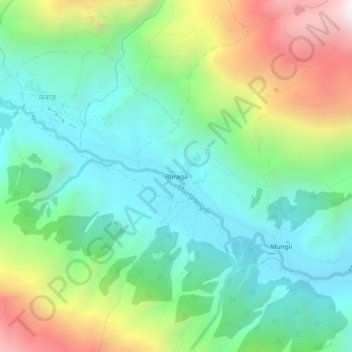
Name: Braka topographic map, elevation, terrain.
Location: Braka, Neshyang-05, Neshyang, Manang, Gandaki Province, Nepal (28.63720 84.01986 28.67720 84.05986)
Average elevation: 12,628 ft
Minimum elevation: 11,237 ft
Maximum elevation: 15,633 ft
Thank you for supporting this site ❤️
Make a donation
Make a donation
Gear up for your next adventure:
As an Amazon Associate, this site earns from qualifying purchases at no extra cost to you.