
Enzensberg topographic map
Click on the map to display elevation.
About this map
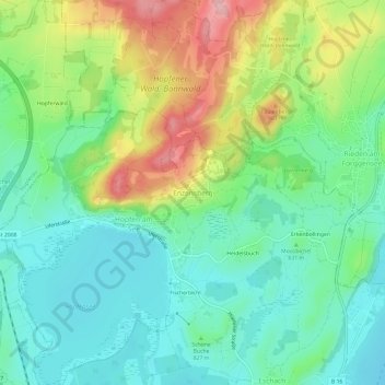
Name: Enzensberg topographic map, elevation, terrain.
Average elevation: 2,723 ft
Minimum elevation: 2,536 ft
Maximum elevation: 3,097 ft
Other topographic maps
Click on a map to view its topography, its elevation and its terrain.
Hopfensee
Deutschland > Bayern > Landkreis Ostallgäu > Füssen > Hopfen am See
Average elevation: 2,621 ft
Alatsee
Deutschland > Bayern > Landkreis Ostallgäu > Füssen
Der Alatsee ist ein meromiktischer See sechs Kilometer westlich von Füssen in Bayern. Er liegt auf 868 Metern Höhe in einer schluchtartigen Senke nur etwa 80 Meter nördlich des Falkensteinkamms mit der Grenze zu Österreich sowie gut 500 Meter südlich des tiefer gelegenen Weißensees. Von diesem ist er…
Average elevation: 2,822 ft