
Make a donation
Gear up for your next adventure:
As an Amazon Associate, this site earns from qualifying purchases at no extra cost to you.
Bischofsdhron topographic map
Click on the map to display elevation.
Make a donation
Gear up for your next adventure:
As an Amazon Associate, this site earns from qualifying purchases at no extra cost to you.
About this map
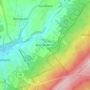
Name: Bischofsdhron topographic map, elevation, terrain.
Average elevation: 1,749 ft
Minimum elevation: 1,365 ft
Maximum elevation: 2,461 ft
Make a donation
Gear up for your next adventure:
As an Amazon Associate, this site earns from qualifying purchases at no extra cost to you.
Other topographic maps
Click on a map to view its topography, its elevation and its terrain.
Wolzburg
Deutschland > Rheinland-Pfalz > Landkreis Bernkastel-Wittlich > Morbach
Average elevation: 1,831 ft
Hoxel
Deutschland > Rheinland-Pfalz > Landkreis Bernkastel-Wittlich > Morbach
Average elevation: 1,686 ft
Heinzerath
Deutschland > Rheinland-Pfalz > Landkreis Bernkastel-Wittlich > Morbach
Average elevation: 1,627 ft
Gonzerath
Deutschland > Rheinland-Pfalz > Landkreis Bernkastel-Wittlich > Morbach > Gonzerath
Average elevation: 1,654 ft
Make a donation
Gear up for your next adventure:
As an Amazon Associate, this site earns from qualifying purchases at no extra cost to you.