
Rayfoun topographic map
Click on the map to display elevation.
Rayfoun
Rayfoun (Arabic: ريفون; also spelled Reifun or Raifoun) is a village and municipality located in the Keserwan District of the Keserwan-Jbeil Governorate of Lebanon. The village is about 28 kilometres (17 mi) north of Beirut. It has an average elevation of 1,050 meters above sea level and a total land area of 189 hectares. Rayfoun's inhabitants are predominantly Maronites. Rayfoun is the hometown of Maronite Patriarch Nasrallah Boutros Sfeir and the Ottoman-era peasant leader Tanyus Shahin.
About this map
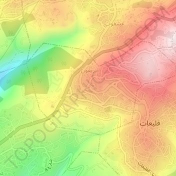
Name: Rayfoun topographic map, elevation, terrain.
Average elevation: 3,248 ft
Minimum elevation: 2,251 ft
Maximum elevation: 4,012 ft
Other topographic maps
Click on a map to view its topography, its elevation and its terrain.
Ballouneh
Lebanon > Keserwan-Jbeil Governorate
Ballouneh (Arabic: بلونة) is a town and municipality in the Keserwan District of the Keserwan-Jbeil Governorate of Lebanon. It is located 18 kilometers north of Beirut. It has an approximate area of 3.93 square kilometers and an average elevation of 650 meters above sea level. Ballouneh's inhabitants are…
Average elevation: 2,133 ft
Kfardebian
Lebanon > Keserwan-Jbeil Governorate
Kfardebian (Arabic: كفر دبيان; also spelled Kfar Dibiane and also known as Moucha'a Keserwan) is a municipality in the Keserwan District of the Keserwan-Jbeil Governorate in Lebanon. It is located 45 kilometers north of Beirut. Its average elevation is 1,220 meters above sea level and its total land…
Average elevation: 5,768 ft