
Make a donation
Gear up for your next adventure:
As an Amazon Associate, this site earns from qualifying purchases at no extra cost to you.
Wittenberge topographic map
Click on the map to display elevation.
Make a donation
Gear up for your next adventure:
As an Amazon Associate, this site earns from qualifying purchases at no extra cost to you.
Wittenberge
In den Jahren 1912–1914 wurde das Wittenberger Rathaus (Turmhöhe 51 m) errichtet, das in seiner monumentalen Ausführung deutlich den großstädtischen Anspruch der aufstrebenden Industriestadt symbolisiert. Dieser Aufbruch wurde durch die Folgen des Ersten Weltkrieges 1914–1918 und die Weltwirtschaftskrise ab Ende der 1920er Jahre gedämpft.
Make a donation
Gear up for your next adventure:
As an Amazon Associate, this site earns from qualifying purchases at no extra cost to you.
About this map
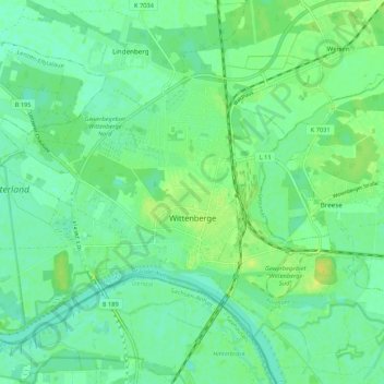
Name: Wittenberge topographic map, elevation, terrain.
Location: Wittenberge, Prignitz, Brandenburg, 19322, Deutschland (52.97731 11.68357 53.02801 11.79033)
Average elevation: 75 ft
Minimum elevation: 49 ft
Maximum elevation: 118 ft
Make a donation
Gear up for your next adventure:
As an Amazon Associate, this site earns from qualifying purchases at no extra cost to you.