Geolocate

Hampshire topographic map

Click on the map to display elevation.

About this map

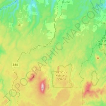
Name: Hampshire topographic map, elevation, terrain.

Location: Hampshire, City of Burnie, Tasmania, Australia (-41.35631 145.62118 -41.22930 145.87740)

Average elevation: 1,647 ft

Minimum elevation: 715 ft

Maximum elevation: 3,524 ft

Other topographic maps

Click on a map to view its topography, its elevation and its terrain.

Cathedral Mountain

Australia > Tasmania

Average elevation: 3,255 ft

Waterworks Reserve

Australia > Tasmania > Hobart

Average elevation: 787 ft

Rowlands Hill

Australia > Tasmania

Average elevation: 1,273 ft

Cradle Mountain

Australia > Tasmania > Cradle Mountain

Average elevation: 3,753 ft

The Nut

Australia > Tasmania > Stanley

Average elevation: 26 ft

Bream Creek

Australia > Tasmania > Bream Creek

Average elevation: 115 ft

Buxton Point

Australia > Tasmania > Little Swanport

Average elevation: 10 ft

Mount Patrick

Australia > Tasmania

Average elevation: 2,831 ft

Mount Ossa

Australia > Tasmania

Average elevation: 3,996 ft

West Gawler River

Australia > Tasmania > Sprent > Gawler

Average elevation: 659 ft

Mount Tyndall

Australia > Tasmania

Average elevation: 2,986 ft

Gear up for your next adventure:

🧯Emergency Survival Kit - All‑in‑one survival essentials for the backcountry
🪶LED Camping Lantern - Bright lantern for camp lighting
👟Men's Trail Runners - Lightweight footwear for fast-paced exploration and light hiking
🛠️Backpacking Tool Kit - Essential toolkit for outdoor repairs
🥘Titanium Cookware - Durable, featherlight pots and pans for backpacking

As an Amazon Associate, this site earns from qualifying purchases at no extra cost to you.