
Thank you for supporting this site ❤️
Make a donation
Make a donation
Gear up for your next adventure:
As an Amazon Associate, this site earns from qualifying purchases at no extra cost to you.
Mukteshwar topographic map
Click on the map to display elevation.
Thank you for supporting this site ❤️
Make a donation
Make a donation
Gear up for your next adventure:
As an Amazon Associate, this site earns from qualifying purchases at no extra cost to you.
About this map
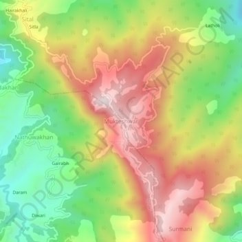
Name: Mukteshwar topographic map, elevation, terrain.
Location: Mukteshwar, Dhari, Nainital, Uttarakhand, 263138, India (29.45208 79.62804 29.49208 79.66804)
Average elevation: 6,503 ft
Minimum elevation: 5,423 ft
Maximum elevation: 7,621 ft
Thank you for supporting this site ❤️
Make a donation
Make a donation
Gear up for your next adventure:
As an Amazon Associate, this site earns from qualifying purchases at no extra cost to you.