Geolocate

Calary topographic map

Click on the map to display elevation.

About this map

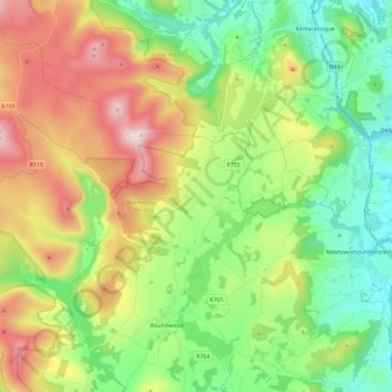
Name: Calary topographic map, elevation, terrain.

Location: Calary, County Wicklow, Leinster, A98 KN50, Ireland (53.05479 -6.34477 53.16345 -6.11379)

Average elevation: 968 ft

Minimum elevation: 157 ft

Maximum elevation: 2,359 ft

Other topographic maps

Click on a map to view its topography, its elevation and its terrain.

Kiltegan

Ireland > County Wicklow

Average elevation: 492 ft

Upper Lake

Ireland > County Wicklow

Average elevation: 1,086 ft

Gear up for your next adventure:

📡GPS Antenna Upgrade - Enhance GPS reception in remote terrain
🧯Portable Fire Pit - Compact fire pit for camping spots
🧥Men's Rain Shells - Premium waterproof and breathable jackets for mountain weather
🧢Sun Protection Hats - Wide-brimmed and UPF-rated hats for high-altitude sun safety
Backpacking Tent - Lightweight and durable tent for multi‑day hikes

As an Amazon Associate, this site earns from qualifying purchases at no extra cost to you.