
Mauck topographic map
Click on the map to display elevation.
About this map
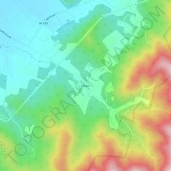
Name: Mauck topographic map, elevation, terrain.
Location: Mauck, Page County, Virginia, United States (38.54040 -78.46640 38.58040 -78.42640)
Average elevation: 1,535 ft
Minimum elevation: 971 ft
Maximum elevation: 2,638 ft
Page County trails, hiking, mountain biking, running and outdoor activities
Other topographic maps
Click on a map to view its topography, its elevation and its terrain.