
Thank you for supporting this site ❤️
Make a donation
Make a donation
Gear up for your next adventure:
As an Amazon Associate, this site earns from qualifying purchases at no extra cost to you.
Felgueiras topographic map
Click on the map to display elevation.
Thank you for supporting this site ❤️
Make a donation
Make a donation
Gear up for your next adventure:
As an Amazon Associate, this site earns from qualifying purchases at no extra cost to you.
About this map
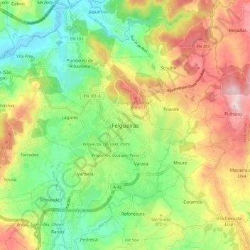
Name: Felgueiras topographic map, elevation, terrain.
Location: Felgueiras, Porto, Tâmega e Sousa, Norte, 4610-122, Portugal (41.32477 -8.23893 41.40477 -8.15893)
Average elevation: 1,056 ft
Minimum elevation: 476 ft
Maximum elevation: 1,850 ft
Thank you for supporting this site ❤️
Make a donation
Make a donation
Gear up for your next adventure:
As an Amazon Associate, this site earns from qualifying purchases at no extra cost to you.
Other topographic maps
Click on a map to view its topography, its elevation and its terrain.