
Make a donation
Gear up for your next adventure:
As an Amazon Associate, this site earns from qualifying purchases at no extra cost to you.
Boente topographic map
Click on the map to display elevation.
Make a donation
Gear up for your next adventure:
As an Amazon Associate, this site earns from qualifying purchases at no extra cost to you.
About this map
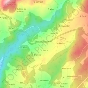
Name: Boente topographic map, elevation, terrain.
Location: Boente, Arzúa, La Coruña, Galicia, 15826, España (42.90765 -8.10251 42.92356 -8.06397)
Average elevation: 1,319 ft
Minimum elevation: 1,050 ft
Maximum elevation: 1,608 ft
Make a donation
Gear up for your next adventure:
As an Amazon Associate, this site earns from qualifying purchases at no extra cost to you.
Other topographic maps
Click on a map to view its topography, its elevation and its terrain.
Make a donation
Gear up for your next adventure:
As an Amazon Associate, this site earns from qualifying purchases at no extra cost to you.
Make a donation
Gear up for your next adventure:
As an Amazon Associate, this site earns from qualifying purchases at no extra cost to you.
Make a donation
Gear up for your next adventure:
As an Amazon Associate, this site earns from qualifying purchases at no extra cost to you.
Make a donation
Gear up for your next adventure:
As an Amazon Associate, this site earns from qualifying purchases at no extra cost to you.
Touro
España > Galicia > Arzúa > Touro
Para hacer un estudio completo de la climatología del ayuntamiento de Touro, se toman datos de la estación meteorológica situada en el aeropuerto de Lavacolla (Altitud(m):364 Latitud: 42 53 58 Longitud: 8 25 37), que es la más cercana al ayuntamiento y con características geográficas parecidas. Los datos…
Average elevation: 981 ft