
Thank you for supporting this site ❤️
Make a donation
Make a donation
Gear up for your next adventure:
As an Amazon Associate, this site earns from qualifying purchases at no extra cost to you.
Eichenweg topographic map
Click on the map to display elevation.
Thank you for supporting this site ❤️
Make a donation
Make a donation
Gear up for your next adventure:
As an Amazon Associate, this site earns from qualifying purchases at no extra cost to you.
About this map
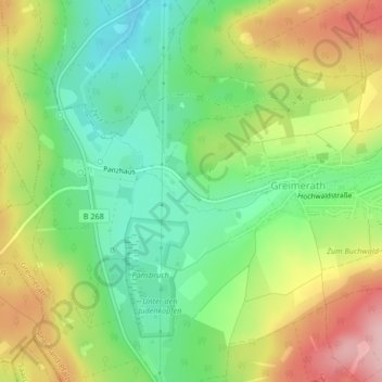
Name: Eichenweg topographic map, elevation, terrain.
Average elevation: 1,512 ft
Minimum elevation: 1,266 ft
Maximum elevation: 1,850 ft
Thank you for supporting this site ❤️
Make a donation
Make a donation
Gear up for your next adventure:
As an Amazon Associate, this site earns from qualifying purchases at no extra cost to you.
Other topographic maps
Click on a map to view its topography, its elevation and its terrain.
Panzbruch bei Greimerath
Deutschland > Rheinland-Pfalz > Landkreis Trier-Saarburg > Greimerath
Average elevation: 1,526 ft