
Make a donation
Gear up for your next adventure:
As an Amazon Associate, this site earns from qualifying purchases at no extra cost to you.
Platanar topographic map
Click on the map to display elevation.
Make a donation
Gear up for your next adventure:
As an Amazon Associate, this site earns from qualifying purchases at no extra cost to you.
About this map
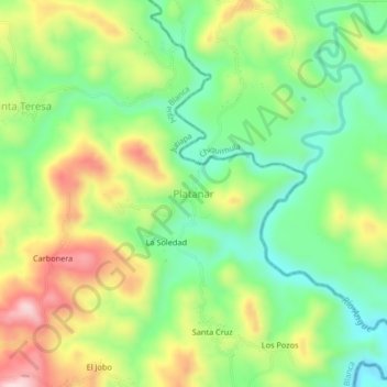
Name: Platanar topographic map, elevation, terrain.
Location: Platanar, Agua Blanca, Jutiapa, Guatemala (14.47075 -89.54090 14.51075 -89.50090)
Average elevation: 2,247 ft
Minimum elevation: 1,827 ft
Maximum elevation: 2,854 ft
Make a donation
Gear up for your next adventure:
As an Amazon Associate, this site earns from qualifying purchases at no extra cost to you.
Other topographic maps
Click on a map to view its topography, its elevation and its terrain.
Area de Uso Multiple Volcán y Laguna de Ipala
Guatemala > Jutiapa > Agua Blanca > Ipala
Average elevation: 3,619 ft
Laguna de Ipala
Guatemala > Jutiapa > Agua Blanca
La laguna de Ipala es un lago de cráter que se localiza entre los departamentos de Chiquimula y Jutiapa en Guatemala. El cráter del Volcán de Ipala tiene un diámetro de aproximadamente 1 km. El lago tiene una superficie de aproximadamente 0.52 km² y se encuentra a una altitud de 1493 m s. n. m.
Average elevation: 4,488 ft