Geolocate

Altaussee topographic map

Click on the map to display elevation.

About this map

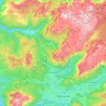
Name: Altaussee topographic map, elevation, terrain.

Location: Altaussee, Bezirk Liezen, Styria, 8992, Austria (47.60205 13.69406 47.72721 13.89592)

Average elevation: 3,934 ft

Minimum elevation: 1,772 ft

Maximum elevation: 6,814 ft

Other topographic maps

Click on a map to view its topography, its elevation and its terrain.

Schafberg

Austria > Styria > Bezirk Liezen > Liezen

Average elevation: 5,220 ft

Gear up for your next adventure:

🧭Hiking Compass - Precision compass for reliable navigation in the wilderness
🦶Carbon Trekking Poles - Reduce knee impact on steep descents with ultra-light poles
🧥Men's Rain Shells - Premium waterproof and breathable jackets for mountain weather
😴Insulated Sleeping Pads - Compact and warm pads for high-elevation camping
🚗GPS Dash Cams - Record your scenic drives through mountain passes and canyons

As an Amazon Associate, this site earns from qualifying purchases at no extra cost to you.