
Thank you for supporting this site ❤️
Make a donation
Make a donation
Gear up for your next adventure:
As an Amazon Associate, this site earns from qualifying purchases at no extra cost to you.
Schafberg topographic map
Click on the map to display elevation.
Thank you for supporting this site ❤️
Make a donation
Make a donation
Gear up for your next adventure:
As an Amazon Associate, this site earns from qualifying purchases at no extra cost to you.
About this map
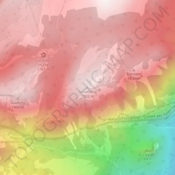
Name: Schafberg topographic map, elevation, terrain.
Location: Schafberg, Liezen, Bezirk Liezen, Styria, 8940, Austria (47.59973 14.17420 47.59983 14.17430)
Average elevation: 5,220 ft
Minimum elevation: 2,651 ft
Maximum elevation: 6,371 ft
Thank you for supporting this site ❤️
Make a donation
Make a donation
Gear up for your next adventure:
As an Amazon Associate, this site earns from qualifying purchases at no extra cost to you.