
Make a donation
Gear up for your next adventure:
As an Amazon Associate, this site earns from qualifying purchases at no extra cost to you.
Huế topographic map
Click on the map to display elevation.
Make a donation
Gear up for your next adventure:
As an Amazon Associate, this site earns from qualifying purchases at no extra cost to you.
Huế
Located near Truong Son mountain range, Hue city is a plain area in the lower reaches of the Perfume and Bo rivers, with an average altitude of 3–4 m above sea level and often flooded when the river's headwaters Huong has medium and large rainfall. This plain area is relatively flat, although there are alternating hills and low mountains such as Ngu Binh mountain and Vong Canh Hill.
Make a donation
Gear up for your next adventure:
As an Amazon Associate, this site earns from qualifying purchases at no extra cost to you.
About this map
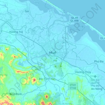
Name: Huế topographic map, elevation, terrain.
Location: Huế, Thừa Thiên Huế Province, 54000, Vietnam (16.32253 107.46826 16.60368 107.67605)
Average elevation: 79 ft
Minimum elevation: -7 ft
Maximum elevation: 1,604 ft
Make a donation
Gear up for your next adventure:
As an Amazon Associate, this site earns from qualifying purchases at no extra cost to you.