
Thank you for supporting this site ❤️
Make a donation
Make a donation
Gear up for your next adventure:
As an Amazon Associate, this site earns from qualifying purchases at no extra cost to you.
barnoli topographic map
Click on the map to display elevation.
Thank you for supporting this site ❤️
Make a donation
Make a donation
Gear up for your next adventure:
As an Amazon Associate, this site earns from qualifying purchases at no extra cost to you.
About this map
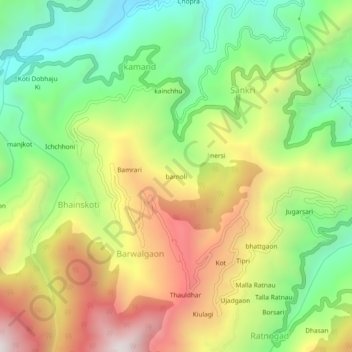
Name: barnoli topographic map, elevation, terrain.
Location: barnoli, Barwalgaon, Tehri, Tehri Garhwal, Uttarakhand, India (30.44014 78.34992 30.48014 78.38992)
Average elevation: 4,377 ft
Minimum elevation: 2,835 ft
Maximum elevation: 6,362 ft
Thank you for supporting this site ❤️
Make a donation
Make a donation
Gear up for your next adventure:
As an Amazon Associate, this site earns from qualifying purchases at no extra cost to you.