
Make a donation
Gear up for your next adventure:
As an Amazon Associate, this site earns from qualifying purchases at no extra cost to you.
Stockum topographic map
Click on the map to display elevation.
Make a donation
Gear up for your next adventure:
As an Amazon Associate, this site earns from qualifying purchases at no extra cost to you.
Stockum
Stockum grenzt in Witten an Annen und Düren und in Dortmund an Oespel, Kley und Salingen. Seit 1929 gehört Stockum zu Witten, davor zum Amt Langendreer. Der Ort liegt auf einer Höhe von 158 m ü. NN. Rund 40 Prozent der Fläche Stockums werden landwirtschaftlich genutzt.
Make a donation
Gear up for your next adventure:
As an Amazon Associate, this site earns from qualifying purchases at no extra cost to you.
About this map
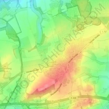
Name: Stockum topographic map, elevation, terrain.
Average elevation: 440 ft
Minimum elevation: 305 ft
Maximum elevation: 574 ft
Make a donation
Gear up for your next adventure:
As an Amazon Associate, this site earns from qualifying purchases at no extra cost to you.
Other topographic maps
Click on a map to view its topography, its elevation and its terrain.
Make a donation
Gear up for your next adventure:
As an Amazon Associate, this site earns from qualifying purchases at no extra cost to you.