
Make a donation
Gear up for your next adventure:
As an Amazon Associate, this site earns from qualifying purchases at no extra cost to you.
Affoltern am Albis topographic map
Click on the map to display elevation.
Make a donation
Gear up for your next adventure:
As an Amazon Associate, this site earns from qualifying purchases at no extra cost to you.
About this map
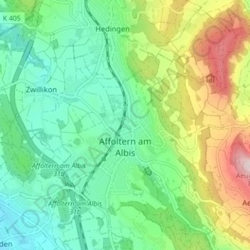
Name: Affoltern am Albis topographic map, elevation, terrain.
Location: Affoltern am Albis, Bezirk Affoltern, Zurich, Suisse (47.26330 8.41467 47.30068 8.47746)
Average elevation: 1,801 ft
Minimum elevation: 1,404 ft
Maximum elevation: 2,657 ft
Make a donation
Gear up for your next adventure:
As an Amazon Associate, this site earns from qualifying purchases at no extra cost to you.
Other topographic maps
Click on a map to view its topography, its elevation and its terrain.
Uetliberg
Suisse > Zurich > Bezirk Affoltern > Stallikon
L'Uetliberg ou Üetliberg (littéralement en allemand : montagne Utli) est un sommet de faible altitude (870 m) formant la limite de la ville de Zurich à l'ouest. Compris entre les rivières Sihl et Reppisch, avec un versant sur la commune de Zurich et l'autre versant, sud-ouest, sur les communes de Uitikon…
Average elevation: 2,047 ft