Geolocate

Tuakau topographic map

Click on the map to display elevation.

About this map

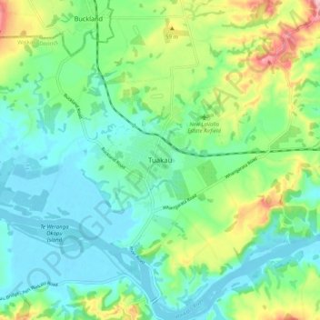
Name: Tuakau topographic map, elevation, terrain.

Location: Tuakau, Waikato District, Waikato, 2121, New Zealand (-37.30259 174.90735 -37.22259 174.98735)

Average elevation: 187 ft

Minimum elevation: 13 ft

Maximum elevation: 630 ft

Other topographic maps

Click on a map to view its topography, its elevation and its terrain.

Lake Whangape

New Zealand > Waikato > Waikato District

Average elevation: 52 ft

Lake Rotokauri

New Zealand > Waikato > Waikato District

Average elevation: 115 ft

Hūnua Ranges

New Zealand > Waikato > Waikato District

Average elevation: 577 ft

Lake Kimihia

New Zealand > Waikato > Waikato District

Average elevation: 112 ft

Lake E

New Zealand > Waikato > Waikato District

Average elevation: 128 ft

Gear up for your next adventure:

Solar GPS Watches - Advanced multisport watches with built-in topographic maps
🔦Compact Flashlight - Reliable flashlight for emergencies
🦟Ultrasonic Repellers - Create a bug-free zone at your camp or rest stop
🚑Emergency Bivvies - Heat-reflective sleeping bags for survival situations
📱Solar Portable Charger - Solar power bank for charging devices off‑grid

As an Amazon Associate, this site earns from qualifying purchases at no extra cost to you.