Geolocate

Cub Run topographic map

Click on the map to display elevation.

About this map

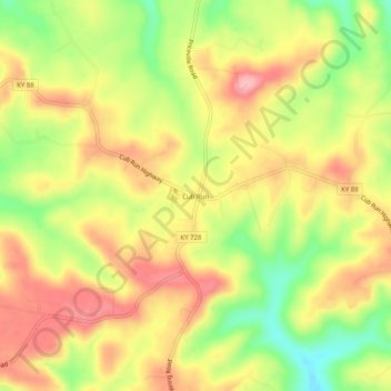
Name: Cub Run topographic map, elevation, terrain.

Location: Cub Run, Hart County, Kentucky, 42729, United States (37.28561 -86.08080 37.32561 -86.04080)

Average elevation: 738 ft

Minimum elevation: 505 ft

Maximum elevation: 922 ft

Hart County trails, hiking, mountain biking, running and outdoor activities

Other topographic maps

Click on a map to view its topography, its elevation and its terrain.

Munfordville

United States > Kentucky > Hart County

Average elevation: 627 ft

Horse Cave

United States > Kentucky > Hart County

Average elevation: 679 ft

Bonnieville

United States > Kentucky > Hart County

Average elevation: 696 ft

Gear up for your next adventure:

🗺️NatGeo Topo Maps - High-quality waterproof printed topographic maps of US Parks
🎒Hydration Pack - Hands‑free water reservoir for long hikes
🧭Orienteering Set - Complete compass and map reading kit
🪶Multi‑Purpose Knife - Useful blade for camp and trail
💧Water Purification System - Clean water on the trail with reliable purifiers

As an Amazon Associate, this site earns from qualifying purchases at no extra cost to you.