
Thank you for supporting this site ❤️
Make a donation
Make a donation
Gear up for your next adventure:
As an Amazon Associate, this site earns from qualifying purchases at no extra cost to you.
Souaflia topographic map
Click on the map to display elevation.
Thank you for supporting this site ❤️
Make a donation
Make a donation
Gear up for your next adventure:
As an Amazon Associate, this site earns from qualifying purchases at no extra cost to you.
About this map
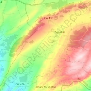
Name: Souaflia topographic map, elevation, terrain.
Location: Souaflia, Bouguirat District, Mostaganem, Algeria (35.79597 0.25571 35.89633 0.37778)
Average elevation: 997 ft
Minimum elevation: 436 ft
Maximum elevation: 1,516 ft
Thank you for supporting this site ❤️
Make a donation
Make a donation
Gear up for your next adventure:
As an Amazon Associate, this site earns from qualifying purchases at no extra cost to you.