
Make a donation
Gear up for your next adventure:
As an Amazon Associate, this site earns from qualifying purchases at no extra cost to you.
Sint-Maria-Horebeke topographic map
Click on the map to display elevation.
Make a donation
Gear up for your next adventure:
As an Amazon Associate, this site earns from qualifying purchases at no extra cost to you.
Sint-Maria-Horebeke
Sint-Maria-Horebeke ligt in de Vlaamse Ardennen en in zandlemig Vlaanderen. De hoogte varieert tussen 25 en 102 meter. Ten westen loopt de Oossebeek en ten oosten de Moldergembeek, beide in noordelijke richting naar de Schelde.
Make a donation
Gear up for your next adventure:
As an Amazon Associate, this site earns from qualifying purchases at no extra cost to you.
About this map
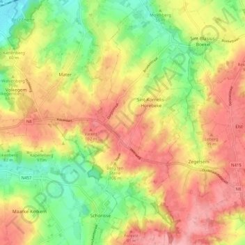
Name: Sint-Maria-Horebeke topographic map, elevation, terrain.
Average elevation: 213 ft
Minimum elevation: 33 ft
Maximum elevation: 367 ft
Make a donation
Gear up for your next adventure:
As an Amazon Associate, this site earns from qualifying purchases at no extra cost to you.
Other topographic maps
Click on a map to view its topography, its elevation and its terrain.
Make a donation
Gear up for your next adventure:
As an Amazon Associate, this site earns from qualifying purchases at no extra cost to you.