Geolocate

Ivalee topographic map

Click on the map to display elevation.

About this map

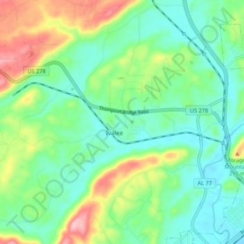
Name: Ivalee topographic map, elevation, terrain.

Location: Ivalee, Etowah County, Alabama, United States (34.00994 -86.18509 34.06455 -86.11064)

Average elevation: 702 ft

Minimum elevation: 518 ft

Maximum elevation: 1,115 ft

Etowah County trails, hiking, mountain biking, running and outdoor activities

Gear up for your next adventure:

🪶Camp Gear Gift Set - Perfect gift bundle for outdoor fans
⛑️Personal Locator Beacon - Safety beacon for emergencies
📡Handheld GPS Device - Reliable handheld GPS for outdoor navigation
🥤Water Filter Bottle - All‑in‑one filter bottle for safe hydration
🏕️Tent Footprint - Protect your tent base from wear

As an Amazon Associate, this site earns from qualifying purchases at no extra cost to you.