
Make a donation
Gear up for your next adventure:
As an Amazon Associate, this site earns from qualifying purchases at no extra cost to you.
Fayette City topographic map
Click on the map to display elevation.
Make a donation
Gear up for your next adventure:
As an Amazon Associate, this site earns from qualifying purchases at no extra cost to you.
Fayette City
Fayette City's low elevation and location along the Monongahela River make it susceptible to flooding after heavy rains. Lamb Lick Run and Downers Run enter the Monongahela within the borough's boundaries.
Make a donation
Gear up for your next adventure:
As an Amazon Associate, this site earns from qualifying purchases at no extra cost to you.
About this map
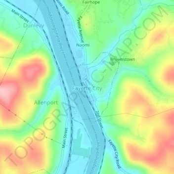
Name: Fayette City topographic map, elevation, terrain.
Location: Fayette City, Fayette County, Pennsylvania, United States (40.09501 -79.84422 40.10589 -79.83409)
Average elevation: 935 ft
Minimum elevation: 755 ft
Maximum elevation: 1,250 ft
Fayette County trails, hiking, mountain biking, running and outdoor activities
Make a donation
Gear up for your next adventure:
As an Amazon Associate, this site earns from qualifying purchases at no extra cost to you.
Other topographic maps
Click on a map to view its topography, its elevation and its terrain.
South Uniontown
United States > Pennsylvania > Fayette County > South Union Township
Average elevation: 1,106 ft
New Meadow Run Bruderhof
United States > Pennsylvania > Fayette County > Wharton Township
Average elevation: 1,913 ft
Morgan Run
United States > Pennsylvania > Fayette County > Dunbar Township
Average elevation: 1,506 ft
West Leisenring
United States > Pennsylvania > Fayette County > Dunbar Township
Average elevation: 1,099 ft
Make a donation
Gear up for your next adventure:
As an Amazon Associate, this site earns from qualifying purchases at no extra cost to you.
Uledi
United States > Pennsylvania > Fayette County > South Union Township
Average elevation: 1,188 ft
Mount Braddock
United States > Pennsylvania > Fayette County > North Union Township
Average elevation: 1,302 ft
Merrittstown
United States > Pennsylvania > Fayette County > Redstone Township
Average elevation: 1,043 ft
Melcroft
United States > Pennsylvania > Fayette County > Saltlick Township
Average elevation: 1,670 ft
Make a donation
Gear up for your next adventure:
As an Amazon Associate, this site earns from qualifying purchases at no extra cost to you.
McClellandtown
United States > Pennsylvania > Fayette County > German Township
Average elevation: 1,109 ft
Leisenring
United States > Pennsylvania > Fayette County > Dunbar Township
Average elevation: 1,129 ft
Lake Lynn
United States > Pennsylvania > Fayette County > Springhill Township
Average elevation: 1,063 ft
Make a donation
Gear up for your next adventure:
As an Amazon Associate, this site earns from qualifying purchases at no extra cost to you.
La Belle
United States > Pennsylvania > Fayette County > Luzerne Township > Luzerne
Average elevation: 971 ft
Keisterville
United States > Pennsylvania > Fayette County > Menallen Township
Average elevation: 1,138 ft
Indian Head
United States > Pennsylvania > Fayette County > Saltlick Township
Average elevation: 1,680 ft
Make a donation
Gear up for your next adventure:
As an Amazon Associate, this site earns from qualifying purchases at no extra cost to you.
Fairbank
United States > Pennsylvania > Fayette County > Redstone Township
Average elevation: 1,086 ft
East Millsboro
United States > Pennsylvania > Fayette County > Luzerne Township
Average elevation: 1,017 ft
Make a donation
Gear up for your next adventure:
As an Amazon Associate, this site earns from qualifying purchases at no extra cost to you.
Star Junction
United States > Pennsylvania > Fayette County > Perry Township
Average elevation: 1,175 ft
Lemont Furnace
United States > Pennsylvania > Fayette County > North Union Township
Average elevation: 1,220 ft
Make a donation
Gear up for your next adventure:
As an Amazon Associate, this site earns from qualifying purchases at no extra cost to you.
New Salem
United States > Pennsylvania > Fayette County > Menallen Township
Average elevation: 1,086 ft
Grindstone
United States > Pennsylvania > Fayette County > Jefferson Township
Average elevation: 1,027 ft
Champion
United States > Pennsylvania > Fayette County > Saltlick Township
Average elevation: 1,657 ft
Make a donation
Gear up for your next adventure:
As an Amazon Associate, this site earns from qualifying purchases at no extra cost to you.
Trotter
United States > Pennsylvania > Fayette County > Dunbar Township > Trotter
Average elevation: 1,056 ft
Tower Hill Number Two
United States > Pennsylvania > Fayette County > Luzerne Township > Tower Hill Number Two
Average elevation: 1,066 ft
Jumonville
United States > Pennsylvania > Fayette County > North Union Township > Jumonville
Average elevation: 2,011 ft
Millertown
United States > Pennsylvania > Fayette County > Saltlick Township
Average elevation: 1,795 ft
Make a donation
Gear up for your next adventure:
As an Amazon Associate, this site earns from qualifying purchases at no extra cost to you.
Mill Run
United States > Pennsylvania > Fayette County > Springfield Township
Average elevation: 1,581 ft
Buena Vista
United States > Pennsylvania > Fayette County > Franklin Township
Average elevation: 1,260 ft
Make a donation
Gear up for your next adventure:
As an Amazon Associate, this site earns from qualifying purchases at no extra cost to you.