Geolocate

Gene Autry topographic map

Click on the map to display elevation.

About this map

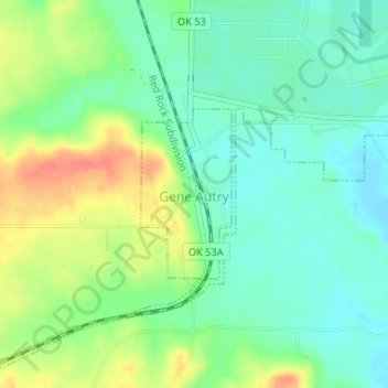
Name: Gene Autry topographic map, elevation, terrain.

Location: Gene Autry, Carter County, Oklahoma, 73436, United States (34.27793 -97.04257 34.28978 -97.03490)

Average elevation: 758 ft

Minimum elevation: 696 ft

Maximum elevation: 856 ft

Carter County trails, hiking, mountain biking, running and outdoor activities

Other topographic maps

Click on a map to view its topography, its elevation and its terrain.

Glenn

United States > Oklahoma > Carter County

Average elevation: 876 ft

Gear up for your next adventure:

🛠️Backpacking Tool Kit - Essential toolkit for outdoor repairs
🌐World Map Poster - Decorative world maps with topographic info
🥾Women's Hiking Boots - Top-rated trail boots with ankle support and superior grip
🛡️Bear Spray Outdoor - Protection in bear country hikes
🛠️Outdoor Gear Repair Kit - Essential tools to fix gear on the trail

As an Amazon Associate, this site earns from qualifying purchases at no extra cost to you.