
Thank you for supporting this site ❤️
Make a donation
Make a donation
Gear up for your next adventure:
As an Amazon Associate, this site earns from qualifying purchases at no extra cost to you.
Vitrival topographic map
Click on the map to display elevation.
Thank you for supporting this site ❤️
Make a donation
Make a donation
Gear up for your next adventure:
As an Amazon Associate, this site earns from qualifying purchases at no extra cost to you.
About this map
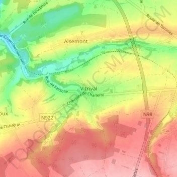
Name: Vitrival topographic map, elevation, terrain.
Location: Vitrival, Fosses-la-Ville, Namur, Wallonia, 5070, Belgium (50.37416 4.63588 50.41416 4.67588)
Average elevation: 633 ft
Minimum elevation: 387 ft
Maximum elevation: 837 ft
Thank you for supporting this site ❤️
Make a donation
Make a donation
Gear up for your next adventure:
As an Amazon Associate, this site earns from qualifying purchases at no extra cost to you.