
Mandai topographic map
Interactive map
Click on the map to display elevation.
About this map
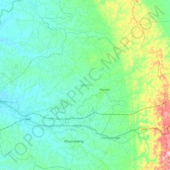
Name: Mandai topographic map, elevation, terrain.
Location: Mandai, West Tripura District, Tripura, India (23.79775 91.33816 23.93669 91.56049)
Average elevation: 210 ft
Minimum elevation: 49 ft
Maximum elevation: 781 ft
Other topographic maps
Click on a map to view its topography, its elevation and its terrain.
Kanchanpur
Kanchanpur, Dasda, North Tripura District, Tripura, 799270, India
Average elevation: 217 ft
Kamalpur
India > Tripura > Durga Chowmuhani
Kamalpur, Durga Chowmuhani, Dhalai District, Tripura, 799285, India
Average elevation: 154 ft