
Make a donation
Gear up for your next adventure:
As an Amazon Associate, this site earns from qualifying purchases at no extra cost to you.
Municipio de Ensenada topographic map
Click on the map to display elevation.
Make a donation
Gear up for your next adventure:
As an Amazon Associate, this site earns from qualifying purchases at no extra cost to you.
About this map
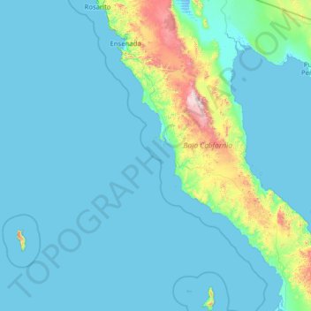
Name: Municipio de Ensenada topographic map, elevation, terrain.
Location: Municipio de Ensenada, Baja California, Mexico (28.02950 -118.36506 32.38623 -113.35724)
Average elevation: 479 ft
Minimum elevation: -10 ft
Maximum elevation: 9,350 ft
Make a donation
Gear up for your next adventure:
As an Amazon Associate, this site earns from qualifying purchases at no extra cost to you.
Other topographic maps
Click on a map to view its topography, its elevation and its terrain.
San Miguel (Cíbolas de Mar)
Mexico > Baja California > Municipio de Ensenada > Ensenada
Average elevation: 187 ft
Make a donation
Gear up for your next adventure:
As an Amazon Associate, this site earns from qualifying purchases at no extra cost to you.
Nueva Colonia Hindú
Mexico > Baja California > Municipio de Tecate > Nueva Colonia Hindú
Average elevation: 2,461 ft
Make a donation
Gear up for your next adventure:
As an Amazon Associate, this site earns from qualifying purchases at no extra cost to you.
Hacienda Casa Grande
Mexico > Baja California > Municipio de Tijuana > Hacienda Casa Grande
Average elevation: 558 ft
Lomas del Valle
Mexico > Baja California > Municipio de Tijuana > Lomas del Valle
Average elevation: 722 ft