Geolocate

Voitsberg topographic map

Click on the map to display elevation.

About this map

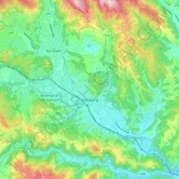
Name: Voitsberg topographic map, elevation, terrain.

Location: Voitsberg, Bezirk Voitsberg, Styria, 8570, Austria (47.01947 15.11350 47.08949 15.21279)

Average elevation: 1,575 ft

Minimum elevation: 1,198 ft

Maximum elevation: 2,415 ft

Other topographic maps

Click on a map to view its topography, its elevation and its terrain.

Muggauberg

Austria > Styria > Bezirk Voitsberg > Stallhofen

Average elevation: 1,434 ft

Hörgas

Austria > Styria > Bezirk Voitsberg > Rosental an der Kainach

Average elevation: 1,555 ft

Packsattel

Austria > Styria > Bezirk Voitsberg > Hirschegg-Pack > Pack

Average elevation: 3,688 ft

Gear up for your next adventure:

🧴Hand Sanitizer - Keep hands clean while hiking
🪶Fire Starter Kit - Reliable fire starter for survival and camping
🛏️Cold Weather Sleeping Bag - Warm sleeping bag for cold conditions
🪄Magnetic Compass - Accurate compass for navigation
🎁Geography Themed Gifts - Unique gift ideas for map lovers and geography enthusiasts

As an Amazon Associate, this site earns from qualifying purchases at no extra cost to you.