Geolocate

College Mound topographic map

Click on the map to display elevation.

About this map

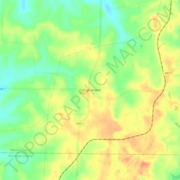
Name: College Mound topographic map, elevation, terrain.

Location: College Mound, Macon County, Missouri, United States (39.60309 -92.59269 39.64309 -92.55269)

Average elevation: 814 ft

Minimum elevation: 728 ft

Maximum elevation: 889 ft

Macon County trails, hiking, mountain biking, running and outdoor activities

Other topographic maps

Click on a map to view its topography, its elevation and its terrain.

Bevier

United States > Missouri > Macon County

Average elevation: 830 ft

La Plata

United States > Missouri > Macon County

Average elevation: 925 ft

Macon

United States > Missouri > Macon County

Average elevation: 837 ft

Elmer

United States > Missouri > Macon County

Average elevation: 751 ft

Gear up for your next adventure:

🕶️Glacier Sunglasses - Side shields to protect eyes from high-altitude snow glare
💧Water Purification System - Clean water on the trail with reliable purifiers
🔥Plasma Lighters - Windproof lighters that work in any weather condition
🔊Portable Camp Speaker - Music and alerts at camp
🏔️Mountain Trail Maps - High‑detail maps for popular peaks

As an Amazon Associate, this site earns from qualifying purchases at no extra cost to you.