
Make a donation
Gear up for your next adventure:
As an Amazon Associate, this site earns from qualifying purchases at no extra cost to you.
Bonython Park topographic map
Click on the map to display elevation.
Make a donation
Gear up for your next adventure:
As an Amazon Associate, this site earns from qualifying purchases at no extra cost to you.
About this map
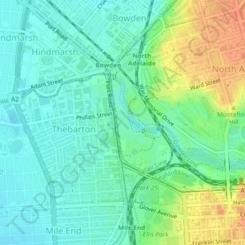
Name: Bonython Park topographic map, elevation, terrain.
Average elevation: 95 ft
Minimum elevation: 49 ft
Maximum elevation: 187 ft
Make a donation
Gear up for your next adventure:
As an Amazon Associate, this site earns from qualifying purchases at no extra cost to you.
Other topographic maps
Click on a map to view its topography, its elevation and its terrain.
Wellington Square
Australia > South Australia > Adelaide City Council > Adelaide
Average elevation: 125 ft
Victoria Square
Australia > South Australia > Adelaide City Council > Adelaide
Average elevation: 154 ft
North Adelaide
Australia > South Australia > Adelaide City Council > Adelaide
Average elevation: 131 ft
Make a donation
Gear up for your next adventure:
As an Amazon Associate, this site earns from qualifying purchases at no extra cost to you.