
Make a donation
Gear up for your next adventure:
As an Amazon Associate, this site earns from qualifying purchases at no extra cost to you.
Lumbisí topographic map
Click on the map to display elevation.
Make a donation
Gear up for your next adventure:
As an Amazon Associate, this site earns from qualifying purchases at no extra cost to you.
About this map
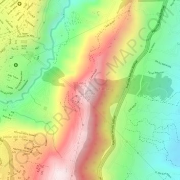
Name: Lumbisí topographic map, elevation, terrain.
Average elevation: 9,085 ft
Minimum elevation: 8,186 ft
Maximum elevation: 10,016 ft
Make a donation
Gear up for your next adventure:
As an Amazon Associate, this site earns from qualifying purchases at no extra cost to you.
Other topographic maps
Click on a map to view its topography, its elevation and its terrain.
Belisario Quevedo
Ecuador > Pichincha > Distrito Metropolitano de Quito > Quito
Average elevation: 11,348 ft
Parque El Heraldo
Ecuador > Pichincha > Distrito Metropolitano de Quito > Quito
Average elevation: 9,245 ft
Parque Metropolitano del Sur
Ecuador > Pichincha > Distrito Metropolitano de Quito > Quito
Average elevation: 9,685 ft
Make a donation
Gear up for your next adventure:
As an Amazon Associate, this site earns from qualifying purchases at no extra cost to you.
San Isidro del Inca
Ecuador > Pichincha > Distrito Metropolitano de Quito > Quito
Average elevation: 9,206 ft
Centro Histórico
Ecuador > Pichincha > Distrito Metropolitano de Quito > Quito
Fue declarado por la Unesco, junto con Cracovia (Polonia), el primer Patrimonio Cultural de la Humanidad el 8 de septiembre de 1978. El centro histórico de Quito fue inscrito en la Lista del Patrimonio Mundial bajo los criterios (ii) y (iv) por representar un importante intercambio de valores sociales entre…
Average elevation: 9,364 ft