Geolocate

Kakrina topographic map

Click on the map to display elevation.

About this map

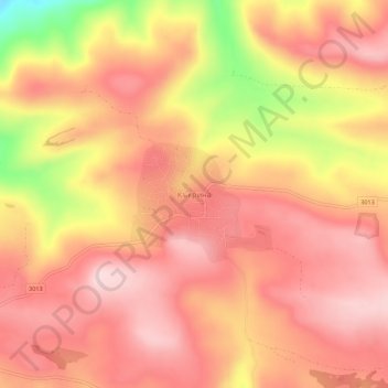
Name: Kakrina topographic map, elevation, terrain.

Location: Kakrina, Lovech, Bulgaria (43.10642 24.86710 43.14642 24.90710)

Average elevation: 1,499 ft

Minimum elevation: 866 ft

Maximum elevation: 1,785 ft

Other topographic maps

Click on a map to view its topography, its elevation and its terrain.

Central Balkan National Park

Bulgaria > Lovech

Average elevation: 2,119 ft

Beli Osam

Bulgaria > Lovech

Average elevation: 2,927 ft

Oreshak

Bulgaria > Lovech

Average elevation: 1,824 ft

Troyan

Bulgaria > Lovech

Average elevation: 2,100 ft

Gear up for your next adventure:

🧺Microfiber Travel Towels - Compact and fast-drying towels for trail use
🛠️Outdoor Gear Repair Kit - Essential tools to fix gear on the trail
🩹Survival Bandages - High‑quality bandages for emergencies
🌄Hiking Binoculars - Compact binoculars for scenic views and trail spotting
🪶Paracord Bracelet - Survival bracelet with built‑in tools

As an Amazon Associate, this site earns from qualifying purchases at no extra cost to you.