Geolocate

Budbrooke topographic map

Click on the map to display elevation.

About this map

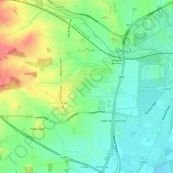
Name: Budbrooke topographic map, elevation, terrain.

Location: Budbrooke, Hampton Magna, Warwick, Warwickshire, England, United Kingdom (52.26174 -1.66361 52.29799 -1.60964)

Average elevation: 233 ft

Minimum elevation: 144 ft

Maximum elevation: 387 ft

Other topographic maps

Click on a map to view its topography, its elevation and its terrain.

Catchem's End

United Kingdom > England > Warwickshire > Warwick > Hatton

Average elevation: 322 ft

Leek Wootton

United Kingdom > England > Warwickshire > Warwick

Average elevation: 249 ft

Chessetts Wood

United Kingdom > England > Warwickshire > Warwick > Lapworth

Average elevation: 377 ft

Haseley Knob

United Kingdom > England > Warwickshire > Warwick > Wroxall

Average elevation: 384 ft

Gear up for your next adventure:

📱Heavy-Duty Phone Cases - Drop-proof and waterproof protection for outdoor navigation
🪶Camping Sleeping Pad - Comfortable sleeping pad for backpacking
🧴Hand Sanitizer - Keep hands clean while hiking
🎒Hydration Pack - Hands‑free water reservoir for long hikes
🧦Merino Wool Socks - Moisture-wicking, blister-preventing socks for long treks

As an Amazon Associate, this site earns from qualifying purchases at no extra cost to you.