
Make a donation
Gear up for your next adventure:
As an Amazon Associate, this site earns from qualifying purchases at no extra cost to you.
Trani topographic map
Click on the map to display elevation.
Make a donation
Gear up for your next adventure:
As an Amazon Associate, this site earns from qualifying purchases at no extra cost to you.
About this map
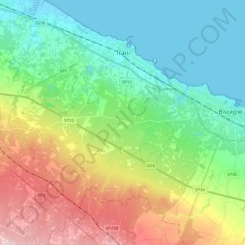
Name: Trani topographic map, elevation, terrain.
Location: Trani, Barletta-Andria-Trani, Apulia, 76125, Italy (41.16127 16.32692 41.30596 16.46760)
Average elevation: 266 ft
Minimum elevation: -7 ft
Maximum elevation: 797 ft
Make a donation
Gear up for your next adventure:
As an Amazon Associate, this site earns from qualifying purchases at no extra cost to you.
Other topographic maps
Click on a map to view its topography, its elevation and its terrain.
Make a donation
Gear up for your next adventure:
As an Amazon Associate, this site earns from qualifying purchases at no extra cost to you.
Make a donation
Gear up for your next adventure:
As an Amazon Associate, this site earns from qualifying purchases at no extra cost to you.
Make a donation
Gear up for your next adventure:
As an Amazon Associate, this site earns from qualifying purchases at no extra cost to you.
Riserva Naturale Regionale Orientata "Bosco delle Pianelle"
Italy > Apulia > Taranto > Martina Franca
Average elevation: 1,345 ft