
Thank you for supporting this site ❤️
Make a donation
Make a donation
Gear up for your next adventure:
As an Amazon Associate, this site earns from qualifying purchases at no extra cost to you.
Quetena topographic map
Click on the map to display elevation.
Thank you for supporting this site ❤️
Make a donation
Make a donation
Gear up for your next adventure:
As an Amazon Associate, this site earns from qualifying purchases at no extra cost to you.
About this map
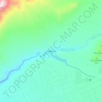
Name: Quetena topographic map, elevation, terrain.
Location: Quetena, Calama, Provincia de El Loa, Antofagasta, Chile (-22.46540 -68.99319 -22.42540 -68.95319)
Average elevation: 7,395 ft
Minimum elevation: 7,031 ft
Maximum elevation: 8,599 ft
Thank you for supporting this site ❤️
Make a donation
Make a donation
Gear up for your next adventure:
As an Amazon Associate, this site earns from qualifying purchases at no extra cost to you.