
Make a donation
Gear up for your next adventure:
As an Amazon Associate, this site earns from qualifying purchases at no extra cost to you.
Portomar topographic map
Click on the map to display elevation.
Make a donation
Gear up for your next adventure:
As an Amazon Associate, this site earns from qualifying purchases at no extra cost to you.
About this map
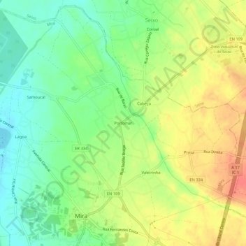
Name: Portomar topographic map, elevation, terrain.
Location: Portomar, Mira, Coimbra, 3070-352, Portugal (40.42357 -8.74823 40.46357 -8.70823)
Average elevation: 98 ft
Minimum elevation: 20 ft
Maximum elevation: 184 ft
Make a donation
Gear up for your next adventure:
As an Amazon Associate, this site earns from qualifying purchases at no extra cost to you.
Other topographic maps
Click on a map to view its topography, its elevation and its terrain.
Seixo
Em 1984 é criada a freguesia civil com sede no Seixo. A elevação a autarquia sub-municipal constituiu o culminar de uma forte demonstração da vontade e um momento alto para as populações dos três lugares que vê a sua emancipação estendida a nível de governo local.
Average elevation: 89 ft