Geolocate

Soong topographic map

Click on the map to display elevation.

About this map

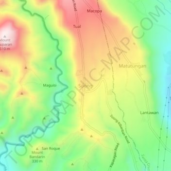
Name: Soong topographic map, elevation, terrain.

Location: Soong, Digos, Davao del Sur, Davao Region, 8002, Philippines (6.79358 125.33510 6.83358 125.37510)

Average elevation: 919 ft

Minimum elevation: 59 ft

Maximum elevation: 1,995 ft

Gear up for your next adventure:

🦺Reflective Outdoor Gear - Safety gear for low‑light conditions
🌄Hiking Binoculars - Compact binoculars for scenic views and trail spotting
🧭Orienteering Set - Complete compass and map reading kit
👓Polarized Sunglasses - Outdoor sunglasses for glare reduction
🦟Ultrasonic Repellers - Create a bug-free zone at your camp or rest stop

As an Amazon Associate, this site earns from qualifying purchases at no extra cost to you.