
Thank you for supporting this site ❤️
Make a donation
Make a donation
Gear up for your next adventure:
As an Amazon Associate, this site earns from qualifying purchases at no extra cost to you.
Costa topographic map
Click on the map to display elevation.
Thank you for supporting this site ❤️
Make a donation
Make a donation
Gear up for your next adventure:
As an Amazon Associate, this site earns from qualifying purchases at no extra cost to you.
About this map
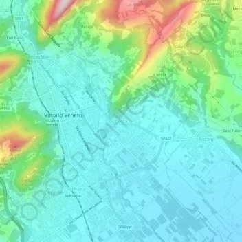
Name: Costa topographic map, elevation, terrain.
Location: Costa, Vittorio Veneto, Treviso, Veneto, 31029, Italia (45.96869 12.29024 46.00869 12.33024)
Average elevation: 630 ft
Minimum elevation: 331 ft
Maximum elevation: 1,654 ft
Thank you for supporting this site ❤️
Make a donation
Make a donation
Gear up for your next adventure:
As an Amazon Associate, this site earns from qualifying purchases at no extra cost to you.