
Make a donation
Gear up for your next adventure:
As an Amazon Associate, this site earns from qualifying purchases at no extra cost to you.
Gómara topographic map
Click on the map to display elevation.
Make a donation
Gear up for your next adventure:
As an Amazon Associate, this site earns from qualifying purchases at no extra cost to you.
About this map
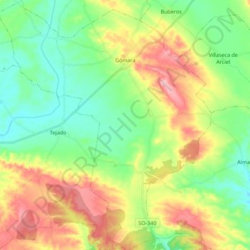
Name: Gómara topographic map, elevation, terrain.
Location: Gómara, Soria, Castile and León, Spain (41.53236 -2.30494 41.65217 -2.16887)
Average elevation: 3,383 ft
Minimum elevation: 3,173 ft
Maximum elevation: 3,727 ft
Make a donation
Gear up for your next adventure:
As an Amazon Associate, this site earns from qualifying purchases at no extra cost to you.
Other topographic maps
Click on a map to view its topography, its elevation and its terrain.
Puente de Domingo Flórez
Spain > Castile and León > El Bierzo > Puente de Domingo Flórez
Average elevation: 1,729 ft
Make a donation
Gear up for your next adventure:
As an Amazon Associate, this site earns from qualifying purchases at no extra cost to you.