
Thank you for supporting this site ❤️
Make a donation
Make a donation
Gear up for your next adventure:
As an Amazon Associate, this site earns from qualifying purchases at no extra cost to you.
Oludeniz topographic map
Click on the map to display elevation.
Thank you for supporting this site ❤️
Make a donation
Make a donation
Gear up for your next adventure:
As an Amazon Associate, this site earns from qualifying purchases at no extra cost to you.
About this map
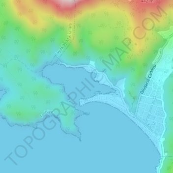
Name: Oludeniz topographic map, elevation, terrain.
Location: Oludeniz, Ölüdeniz, Fethiye, Muğla, Aegean Region, Turkey (36.54825 29.10342 36.55567 29.11772)
Average elevation: 312 ft
Minimum elevation: 0 ft
Maximum elevation: 1,654 ft
Thank you for supporting this site ❤️
Make a donation
Make a donation
Gear up for your next adventure:
As an Amazon Associate, this site earns from qualifying purchases at no extra cost to you.