
Make a donation
Gear up for your next adventure:
As an Amazon Associate, this site earns from qualifying purchases at no extra cost to you.
Ulleungdo Island topographic map
Click on the map to display elevation.
Make a donation
Gear up for your next adventure:
As an Amazon Associate, this site earns from qualifying purchases at no extra cost to you.
Ulleungdo Island
Ulleungdo (also spelled Ulreungdo; Hangul: 울릉도, IPA: [uɭːɯŋdo]) is a South Korean island 120 kilometres (65 nmi; 75 mi) east of the Korean Peninsula in the Sea of Japan, formerly known as Dagelet Island or Argonaut Island in Europe and sometimes referred to as Matsushima on 19th-century maps. Volcanic in origin, the rocky steep-sided island is the top of a large stratovolcano which rises from the seafloor, reaching a maximum elevation of 984 metres (3,228 ft) at Seonginbong Peak. The island is 9.5 kilometres (5.9 mi) in length and 10 kilometres (6.2 mi) in width; it has an area of 72.86 km2 (28.13 sq mi). It has a population of 10,426 inhabitants.
Make a donation
Gear up for your next adventure:
As an Amazon Associate, this site earns from qualifying purchases at no extra cost to you.
About this map
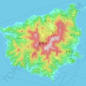
Name: Ulleungdo Island topographic map, elevation, terrain.
Average elevation: 620 ft
Minimum elevation: -7 ft
Maximum elevation: 3,120 ft
Make a donation
Gear up for your next adventure:
As an Amazon Associate, this site earns from qualifying purchases at no extra cost to you.