Dee topographic map
Interactive map
Click on the map to display elevation.
About this map
![Dee topographic map, elevation, terrain](/pub/maps/node/6cs8/dkx8xz4/thumbnail.jpg)
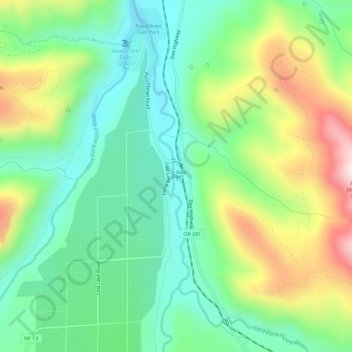
Name: Dee topographic map, elevation, terrain.
Location: Dee, Hood River County, Oregon, United States (45.56758 -121.64786 45.60758 -121.60786)
Average elevation: 1,391 ft
Minimum elevation: 774 ft
Maximum elevation: 2,575 ft
Other topographic maps
Click on a map to view its topography, its elevation and its terrain.
![Hood River topographic map, elevation, terrain](/pub/maps/relation/6814/wn7tf/icon.jpg)
Hood River
United States > Oregon > Hood River County
Hood River, Hood River County, Oregon, United States
Average elevation: 367 ft
![Parkdale topographic map, elevation, terrain](/pub/maps/relation/5wt6/91kzs/icon.jpg)
Parkdale
United States > Oregon > Hood River County > Parkdale
Parkdale, Hood River County, Oregon, United States
Average elevation: 1,765 ft
![Odell topographic map, elevation, terrain](/pub/maps/relation/l8gt/n6v3q/icon.jpg)
Odell
United States > Oregon > Hood River County
Odell, Hood River County, Oregon, United States
Average elevation: 801 ft
![Badger Lake Dam topographic map, elevation, terrain](/pub/maps/node/54kl/jxln8z4/icon.jpg)
Badger Lake Dam
United States > Oregon > Hood River County
Badger Lake Dam, Hood River County, Oregon, United States
Average elevation: 5,135 ft
![Mount Hood topographic map, elevation, terrain](/pub/maps/node/g1h/l42m9tj/icon.jpg)
Mount Hood
United States > Oregon > Hood River County
Mount Hood, Hood River County, Oregon, United States
Average elevation: 8,911 ft
![Government Cove topographic map, elevation, terrain](/pub/maps/node/lcnh/jhrx4z4/icon.jpg)
Government Cove
United States > Oregon > Hood River County > Cascade Locks
Government Cove, Cascade Locks, Hood River County, Oregon, United States
Average elevation: 292 ft
![Cascade Locks Marine Park topographic map, elevation, terrain](/pub/maps/way/zjt6/mrk82kl/icon.jpg)
Cascade Locks Marine Park
United States > Oregon > Hood River County > Cascade Locks
Cascade Locks Marine Park, Cascade Locks, Hood River County, Oregon, United States
Average elevation: 236 ft
![Columbia River topographic map, elevation, terrain](/pub/maps/relation/wgtf/2xksnx/icon.jpg)
Columbia River
United States > Oregon > Hood River County > Cascade Locks
Columbia River, Cascade Locks, Hood River County, Oregon, United States
Average elevation: 1,781 ft
![Cascade Locks topographic map, elevation, terrain](/pub/maps/relation/8n51/dz3z4/icon.jpg)
Cascade Locks
United States > Oregon > Hood River County
Cascade Locks, Hood River County, Oregon, United States
Average elevation: 331 ft
![Shellrock Spring topographic map, elevation, terrain](/pub/maps/node/pm2/rqvkc7nx/icon.jpg)
Shellrock Spring
United States > Oregon > Hood River County
Shellrock Spring, Forest Road 17, Hood River County, Oregon, United States
Average elevation: 3,796 ft