
Make a donation
Gear up for your next adventure:
As an Amazon Associate, this site earns from qualifying purchases at no extra cost to you.
Trittau topographic map
Click on the map to display elevation.
Make a donation
Gear up for your next adventure:
As an Amazon Associate, this site earns from qualifying purchases at no extra cost to you.
Trittau
Die Hälfte des Gemeindegebietes ist von Wald bedeckt, der Siedlungsbereich wird nach Osten durch die Mühlau begrenzt, die im südlichen Bereich der Gemeinde zum Mühlenteich aufgestaut ist und in die Bille mündet. Trittau liegt im Stormarner Endmoränengebiet und das Gelände weist eine entsprechend bewegte Topographie auf. Höchste Erhebung ist der Kleine Hahnheider Berg mit 101,1 m ü. NHN.
Make a donation
Gear up for your next adventure:
As an Amazon Associate, this site earns from qualifying purchases at no extra cost to you.
About this map
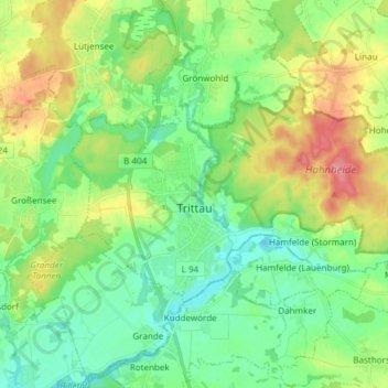
Name: Trittau topographic map, elevation, terrain.
Average elevation: 161 ft
Minimum elevation: 69 ft
Maximum elevation: 331 ft
Make a donation
Gear up for your next adventure:
As an Amazon Associate, this site earns from qualifying purchases at no extra cost to you.
Other topographic maps
Click on a map to view its topography, its elevation and its terrain.
Norddeutsches Tiefland
Deutschland > Schleswig-Holstein > Kreis Stormarn > Trittau
Das Euozeanische Klima prägt die Nordseeküste und die vorgelagerten Ostfriesischen Inseln und Nordfriesischen Inseln. Nach Süden schließt sich ein breiter Streifen ozeanisch (= atlantisch) bzw. subozeanisch geprägten Klimas an, der sich von der Ostküste Schleswig-Holsteins bis zu den westlichen…
Average elevation: 118 ft
Make a donation
Gear up for your next adventure:
As an Amazon Associate, this site earns from qualifying purchases at no extra cost to you.
Make a donation
Gear up for your next adventure:
As an Amazon Associate, this site earns from qualifying purchases at no extra cost to you.
Theodor-Wulff-Höhe
Deutschland > Schleswig-Holstein > Kreis Stormarn > Barsbüttel
Average elevation: 105 ft
Make a donation
Gear up for your next adventure:
As an Amazon Associate, this site earns from qualifying purchases at no extra cost to you.