
Make a donation
Gear up for your next adventure:
As an Amazon Associate, this site earns from qualifying purchases at no extra cost to you.
Sassenbroek topographic map
Click on the map to display elevation.
Make a donation
Gear up for your next adventure:
As an Amazon Associate, this site earns from qualifying purchases at no extra cost to you.
Sassenbroek
Het omliggende landschap wordt gekenmerkt door een glooiend reliëf en de vruchtbare gronden zijn uitermate geschikt voor akkerbouw. De hoogte in dit gebied varieert tussen de 65 en 87 meter.
Make a donation
Gear up for your next adventure:
As an Amazon Associate, this site earns from qualifying purchases at no extra cost to you.
About this map
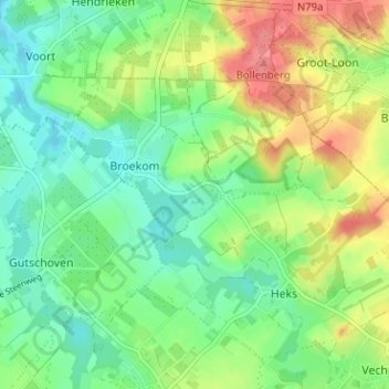
Name: Sassenbroek topographic map, elevation, terrain.
Average elevation: 266 ft
Minimum elevation: 177 ft
Maximum elevation: 413 ft
Make a donation
Gear up for your next adventure:
As an Amazon Associate, this site earns from qualifying purchases at no extra cost to you.
Other topographic maps
Click on a map to view its topography, its elevation and its terrain.
Kasteel van Gors
België > Limburg > Tongeren > Borgloon > Gors-Opleeuw > Gors
Average elevation: 240 ft