
Make a donation
Gear up for your next adventure:
As an Amazon Associate, this site earns from qualifying purchases at no extra cost to you.
Bowman Lake topographic map
Click on the map to display elevation.
Make a donation
Gear up for your next adventure:
As an Amazon Associate, this site earns from qualifying purchases at no extra cost to you.
About this map
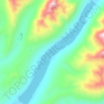
Name: Bowman Lake topographic map, elevation, terrain.
Location: Bowman Lake, Flathead County, Montana, United States (48.82808 -114.20205 48.90613 -114.11482)
Average elevation: 5,377 ft
Minimum elevation: 4,012 ft
Maximum elevation: 8,976 ft
Flathead County trails, hiking, mountain biking, running and outdoor activities
Make a donation
Gear up for your next adventure:
As an Amazon Associate, this site earns from qualifying purchases at no extra cost to you.
Other topographic maps
Click on a map to view its topography, its elevation and its terrain.
Make a donation
Gear up for your next adventure:
As an Amazon Associate, this site earns from qualifying purchases at no extra cost to you.
Kalispell
United States > Montana > Flathead County > Kalispell
Kalispell is located at 48°11′52″N 114°18′58″W / 48.19778°N 114.31611°W / 48.19778; -114.31611 (48.197801, −114.316068), at an elevation of 2,956 feet (901 m).
Average elevation: 3,461 ft
Make a donation
Gear up for your next adventure:
As an Amazon Associate, this site earns from qualifying purchases at no extra cost to you.
Make a donation
Gear up for your next adventure:
As an Amazon Associate, this site earns from qualifying purchases at no extra cost to you.