
Chugiak topographic map
Click on the map to display elevation.
About this map
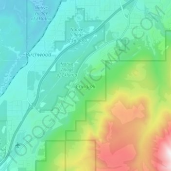
Name: Chugiak topographic map, elevation, terrain.
Location: Chugiak, Anchorage, Alaska, United States (61.34307 -149.55271 61.40472 -149.43473)
Average elevation: 968 ft
Minimum elevation: 16 ft
Maximum elevation: 4,101 ft
Alaska trails, hiking, mountain biking, running and outdoor activities
Other topographic maps
Click on a map to view its topography, its elevation and its terrain.
Alyeska
United States > Alaska > Anchorage > Girdwood
Alyeska has a subarctic climate (Köppen: Dfc), with short but mild summers and long, snowy winters. Snowfall is extremely heavy, owing to the Aleutian Low, with an average year getting 209 inches (530 cm) of snow at the base (elevation 250 feet above sea level) and an average exceeding 650 inches (17 meters)…
Average elevation: 840 ft
Flattop Mountain
United States > Alaska > Anchorage
It is usually reached by driving to the Glen Alps trailhead and following a 1.5-mile (2.4-km) trail, with an elevation gain of 1,280 feet (390 m) from the parking lot to the plateau. Off the plateau loop is a difficult trail to the peak. Since it is the most accessible mountain to Anchorage, Flattop is a very…
Average elevation: 2,411 ft