
Thank you for supporting this site ❤️
Make a donation
Make a donation
Gear up for your next adventure:
As an Amazon Associate, this site earns from qualifying purchases at no extra cost to you.
Katwara topographic map
Click on the map to display elevation.
Thank you for supporting this site ❤️
Make a donation
Make a donation
Gear up for your next adventure:
As an Amazon Associate, this site earns from qualifying purchases at no extra cost to you.
About this map
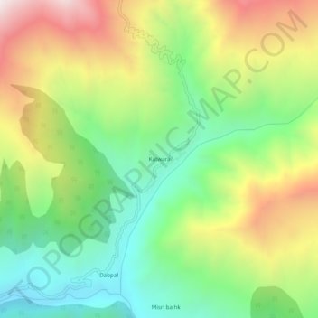
Name: Katwara topographic map, elevation, terrain.
Location: Katwara, Kupwara, Jammu and Kashmir, India (34.67311 74.45994 34.71311 74.49994)
Average elevation: 9,619 ft
Minimum elevation: 7,779 ft
Maximum elevation: 12,303 ft
Thank you for supporting this site ❤️
Make a donation
Make a donation
Gear up for your next adventure:
As an Amazon Associate, this site earns from qualifying purchases at no extra cost to you.