
贵德县 topographic map
Interactive map
Click on the map to display elevation.
About this map
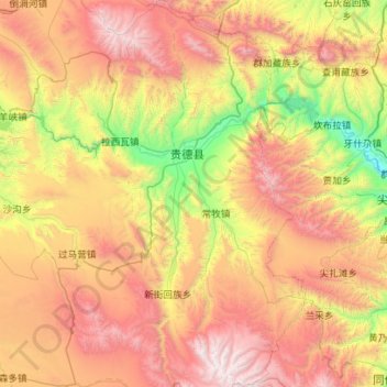
Name: 贵德县 topographic map, elevation, terrain.
Location: 贵德县, 海南藏族自治州, Qinghai, Chine (35.49617 100.96510 36.40311 101.77228)
Average elevation: 10,594 ft
Minimum elevation: 6,568 ft
Maximum elevation: 16,316 ft
Other topographic maps
Click on a map to view its topography, its elevation and its terrain.
གདང་ལ་ 唐古拉山镇
གདང་ལ་ 唐古拉山镇, 格尔木市, Haixi, Qinghai, Chine
Average elevation: 14,997 ft
上红科乡
Chine > Qinghai > Xian de Darlag
上红科乡, Xian de Darlag, Préfecture autonome tibétaine golog, Qinghai, Chine
Average elevation: 14,091 ft
Xian de Madoi
Chine > Qinghai > Xian de Madoi > Xian de Madoi
Xian de Madoi, Préfecture autonome tibétaine golog, Qinghai, Chine
Average elevation: 14,183 ft
Préfecture autonome mongole et tibétaine de Haixi
Préfecture autonome mongole et tibétaine de Haixi, Qinghai, Chine
Average elevation: 12,874 ft
Tanggula Mountains
Chine > Qinghai > ཡན་ཤིས་ཕིན་ 雁石坪镇
Tanggula Mountains, ཡན་ཤིས་ཕིན་ 雁石坪镇, 格尔木市, Préfecture autonome mongole et tibétaine de Haixi, Qinghai, Chine
Average elevation: 19,396 ft
རྨ་ལྷོ་བོད་རིགས་རང་སྐྱོང་ཁུལ་ 黄南藏族自治州
རྨ་ལྷོ་བོད་རིགས་རང་སྐྱོང་ཁུལ་ 黄南藏族自治州, Qinghai, 811599, Chine
Average elevation: 11,378 ft